Watching the Weather
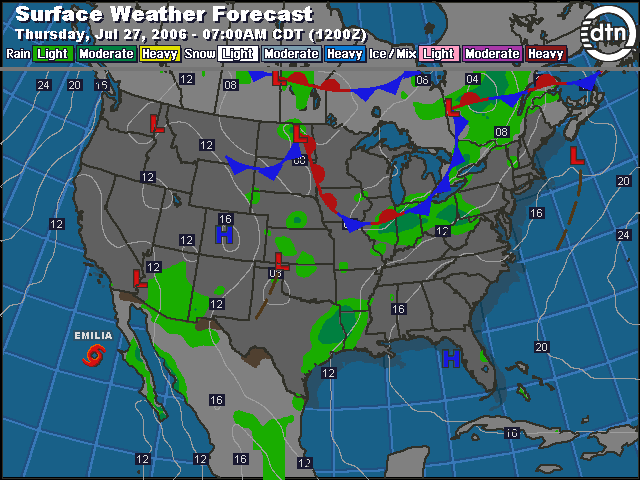
Our hotel in Des Moines had internet access, so on Wednesday evening I was able to get a good idea of what Thursday morning’s weather would be for our planned flight to Manassas, Virginia with a fuel stop in Fort Wayne, Indiana. The 12-hour forecast (for 7:00 am CDT Thursday) showed a stationary front draped across the southern border of Iowa and stretching across Indiana where it turned into a cold front. Light to moderate rain was forecast across the bulk of our route. This wouldn’t be a beautiful VFR flight, but IFR was still a possibility. In the morning we would have to check again to see if that cold front was positioned as forecast, and what kind of weather it was making.

Thursday Morning
The alarm started beeping at 5:30 am CDT on Thursday morning. This morning’s agenda was to check weather and file our IFR flight plans, head downstairs for breakfast in the hotel, and then off to the airport. Elliott Aviation had already fueled the Mooney, so all that was required was a preflight inspection and getting the cockpit organized for the flight. We planned to take off at 8:00 am.
Weather Briefing
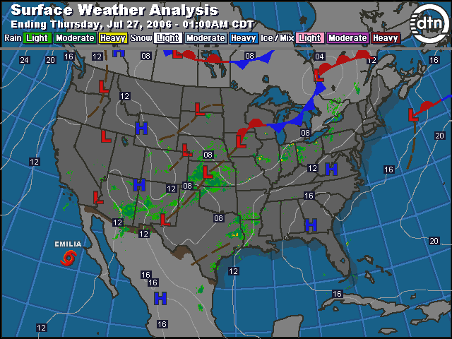
Before reading any of the text forecasts, or talking to a Flight Service briefer, I pulled up the latest surface analysis picture (keeping in mind it was about 4 hours old). This was the best way to get an overall view of the weather before diving into the details. The actual conditions looked a bit better than last night’s forecast. The frontal system was still north of Illinois and Indiana, but it was clearly going to move south during the time of our flight. There was a low pressure center sitting right on top of Des Moines, but it looked like we’d be in good shape through Illinois. Some rain was already falling across Indiana with a few storm cells visible on radar. Chances are we’d get some more time in the clouds before our arrival in Fort Wayne.
I downloaded the latest text weather for our route and looked it over before phoning Flight Service for a telephone weather briefing. Having an idea of the overall weather picture before talking to a preflight briefer makes it a lot easier to fully grasp what the briefer is saying. The weather was pretty good throughout the portion of our route in Iowa and Illinois. The forecast for Iowa called for scattered clouds at 10,000 feet and isolated thunderstorms later in the day. The Illinois forecast was for low clouds, with tops at 3,000 feet. A pilot report from Kankakee (now that’s just a fun name to say) said the cloud tops were between 1,700 and 3,600 feet. That would be well below our planned cruising altitude of 7,000 feet. The pilot report also confirmed that the Illinois forecast was fairly accurate so far. That was a good sign.
The clouds were forecast to thicken as we got into Indiana. The Fort Wayne airport forecast called for overcast skies at 1,500 feet above ground level. One of the two main runways at Fort Wayne was closed, and the remaining runway 5/23 had construction under way so the northeast 3,900 feet were closed. That still left 8,100 feet of runway available on runway 5/23. The winds were forecast to favor runway 23, so we’d have to clear the 3,900-foot displaced threshold on that runway before touching down.
Humidity dominated the weather again today. We left the hotel by 7:15 am and the temperature was already 75 degrees with 90 percent humidity. We were both dripping with sweat by the time we were done loading the airplane and ready for engine start. We’re clearly acclimated to the dry air of Boise.
Flight 5: Des Moines, IA to Fort Wayne, IN
The engine came to life with no problems. Our newly installed starter was doing its job and we were both thrilled to hear the comforting sound of the first engine start of the day.
We tuned to the ATIS frequency and heard, “Des Moines airport information Mike, 1254 Zulu weather, wind calm, visibility 4 haze, few clouds 15,000, overcast 25,000, temperature 25, dew point 23, altimeter 29.82. Landing and departing runway 31. Advise on initial contact you have information Mike.” I wrote down, “M 1254Z CLM V4 HZ FEW150 OVC250 25/23 A29.82. RW31.”

I switched to the clearance delivery frequency and requested our IFR clearance, “Des Moines clearance, Mooney 201UT, IFR, Fort Wayne with Mike.” Clearance called back with, “Mooney 201UT is cleared to the Fort Wayne airport via the Des Moines Five departure then as filed. Maintain 5,000, expect 7,000 ten minutes after departure. Departure frequency 123.9, squawk 3017.” I used the CRAFT template to copy the clearance:
C FWA
R DSM5 AF
A 5000 XP 7000/10
F 123.90
T 3017
We were then cleared to taxi to runway 31, and we pulled into a corner just clear of the runway to complete our run up. We got our take off clearance right away, and we climbed out into beautiful clear skies, with just a few clouds dotting the horizon. I knew the clouds would get lower and thicken into an overcast layer as we proceeded east.

Des Moines departure gave us a few vectors to work us around traffic in the area, and then told us to, “climb and maintain 7,000, cleared direct Fort Wayne.” After a couple of button pushes our IFR certified Garmin 430 GPS started pointing the way to our destination, which was almost 400 nautical miles away. Nancy and I had worked out a flight plan with 4 checkpoints between Des Moines and Fort Wayne. With our new direct clearance, we still tracked our progress against the flight plan as best we could by noting the times we passed abeam our checkpoints.

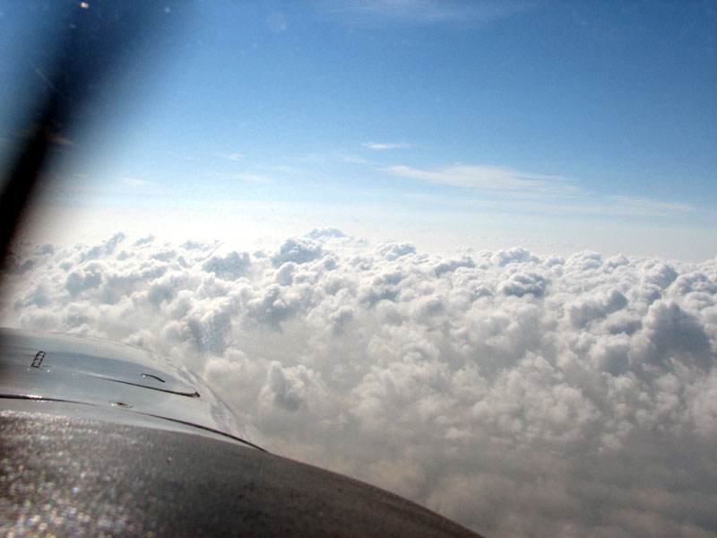
We flew just south of Iowa City, which was our first overnight stop during our 2003 trip across the country We could see the clouds starting to build ahead of us here with a layer of popcorn cumulus appearing just below our 7,000-foot altitude. In the distance we could there were few buildups towering up above 7,000 feet. Those buildups contain very unstable air, and would likely turn into thunderstorms later. We made a few minor course changes to fly around the buildups instead of attempting to fly through them.
About 30 nautical miles east of the MZV VOR there were several tall buildups in our path. I called Chicago Center, and let them know that we needed to deviate 30 degrees to the right to get around that weather. (You can see our course change on the map between MZV and TRIDE.) Center approved our deviation, “Deviation right of course approved. Advise when you are able direct Fort Wayne.”
After about 20 miles on our new heading, we had a good berth around the buildups and I could see that the path to Fort Wayne would now be clear, so I let Chicago Center know we were back on course.
Turn Left NOW!
The flight was progressing smoothly as we continued east towards Fort Wayne. We had been on with Chicago Center for a while, and had become accustomed to the controller’s voice that was working this sector. Just south of Chicago, something unusual happened. A different controller’s voice came over the radio, “Mooney 1UT, turn left to heading 010.” We were both surprised by the request to turn 80 degrees to the left. I started turning immediately.

This was the most drastic vector we had ever received at a cruise altitude and you could definitely hear urgency in the new controller’s voice. After we started turning, we could hear the original controller’s voice back on the frequency giving routine instructions to other aircraft. Shortly after we got to heading 010, the different voice that gave us the vector came back on the frequency and cleared us to again proceed direct to Fort Wayne. The whole detour took approximately 30 seconds and we never saw another airplane. We concluded that the controller who was working this frequency was probably in training, and the different voice that vectored us was likely his trainer keeping the student out of trouble. Controllers are required to have a certain amount of lateral and/or vertical separation between aircraft and my guess is the trainee controller was getting close to not having the proper separation between us and another aircraft.
Instrument Approach to Fort Wayne
Other than our exciting 30-second detour, the rest of the flight was quite mellow. As we neared Fort Wayne, it was time to prepare for the procedure we’d need to follow to find the airport through the clouds. At this point we were about 60 minutes out of Fort Wayne, and I checked the current weather there using our Garmin 396. The winds at Fort Wayne were reported as 210@14 so runway 23 would be the runway in use. The weather report from Fort Wayne also said there were broken clouds at 1,900 and an overcast layer at 2,300. We fired up the Tablet PC and reviewed the VOR 23 approach. The RNAV (GPS) 23 approach would have been preferable, but that was NOTAM’d as “PROCEDURE NA” (procedure not authorized).
Nancy and I had practiced flying approaches using the Tablet PC for viewing approach plates several times before this trip. We used our flight simulator at home to refine how we’d work together to fly an instrument approach. Once we had that ironed out, we practiced doing approaches in the Mooney using the Tablet PC. This would be the day all that practice would pay off. We were about to fly our first real approach through the clouds with Nancy actively helping me through the approach. We’ve done a few approaches through the clouds on previous occasions, but Nancy had basically been a passenger since we hadn’t talked about the details of how instrument approaches work. This time she’d be an important part of the crew.
Because Phil is instrument rated and I’m not, his workload during an approach is much more demanding than my supportive role. In the beginning, my main task was to not ask unnecessary questions during the approach (yes, I learned that the hard way). Over time my responsibilities grew as I learned to understand the terminology and procedures for flying in the clouds. I really like the idea of balancing the workload between us. I know it makes Phil’s job easier and I definitely enjoy participating instead of observing. I’ve toyed with the idea of getting my instrument rating and this has been a great way to ease into it.

I briefed the approach out loud and Nancy made sure I didn’t miss anything. “We’re doing the VOR RWY 23 approach to Fort Wayne. The VORTAC is 117.8, so let’s get that tuned and identified on both NAV radios.” Nancy turned the dials and pushed the appropriate buttons so we could hear the Morse code identifier that confirmed we had the right frequency dialed in, and the VORTAC was operating properly. “The final approach course is 218, and we’ll have 8,100 feet of runway available to us due to the construction on runway 23. The touchdown zone elevation is 799. The initial missed approach is a climbing left turn to 3,000 via the Fort Wayne 128 radial.” I dialed in the 128 radial on the number two navigation indicator. I left the number one navigation indicator alone, since we were still using that to fly our current clearance direct to the Fort Wayne airport. Next we set up our radios so we’d be ready to get the Fort Wayne ATIS, then talk to Fort Wayne approach, then tower, and finally ground control.
I continued with the approach briefing, “We’ll probably get vectors to the final approach course, but if we don’t then we’ll do the published holding pattern at ZOLNR at 3,000 feet in lieu of a procedure turn. Once we’re cleared for the approach we maintain 3,000 then it’s down to 2,300 after ZOLNR, then 1,500 after the FAF at LUERS, and after LINCY we can descend to the MDA of 1,300 and 1 mile visibility is required. The missed approach point is the FWA 0.5 DME, and I’ll set the timer for 3:00 minutes from the FAF. There’s a note about the VGSI not matching the descent angle. The minimum safe altitude is 2,700.”
The approach briefing is an extremely helpful step. It gives me a good idea of what information Phil will be looking for during the approach. Also, this advance briefing is a great time to ask questions so that I don’t interrupt his concentration during the approach. I do the approach briefing out loud even if I’m flying alone. Talking through the procedure in detail is a great review before actually flying it. Following the charted procedure is important, since that’s the only way to safely get to the airport through the clouds.
Around 50 miles west of Fort Wayne we were instructed to descend to 5,000 feet and we entered solid clouds. The air was generally smooth with the occasional bump. Our conversation became quiet so we could both focus on the approach. The term for this is “sterile cockpit” — the only conversation we had was related to the task at hand. We both felt well prepared for the current weather conditions. Phil focused on flying. I kept an eye on the instruments as well, but I couldn’t resist the temptation to look for the ground now and then.
As we got closer to Fort Wayne, we could pick up the ATIS: “Fort Wayne information Tango 1554Z. Wind 210@14, visibility 10, sky broken 1,900 overcast 2,300. Temperature 24, dew point 22, altimeter 29.92. Landing and departing runway 23. The northeast 3,000 feet of runway 5/23 is closed; 8,100 feet available. Advise on initial contact you have information Tango.”
The ATIS matched the weather we were able to view on the display of the Garmin 396 GPS. With 10 miles visibility and an overcast layer at 2,300 AGL, I told Nancy that we should expect to see the airport right around LUERS — or about 5 miles from the runway.
Around 10 miles from the airport we got our first vector from Fort Wayne approach, “Mooney 1UT, turn left heading 050, vectors for the VOR 23 approach.” This put us on the downwind leg for the approach. We could expect two or three more vectors to the right to get us lined up with the final approach course. We had previously loaded the VOR 23 approach in the GPS, and now it was time to activate it. Even when getting vectors to final, I almost never activate the “vectors to final” mode on the GPS, because in that mode it does not show the waypoints that precede the FAF. I wanted to be able to see ZOLNR to known when it was safe to descend to 2,300 feet. Since we were on a vector, I could now set the number one navigation indicator to the approach course of 218°.
After a few more vectors to get us in the right position, we got the approach clearance, “Mooney 1UT is 4 miles from ZOLNR, turn right heading 190, maintain 3,000 until established, cleared VOR runway 23 approach.” I turned to the new heading and double-checked that everything was set properly. I verified that the panel-mounted Garmin 430 GPS was set to VLOC mode so the VOR signal (and not the GPS) was driving the number one navigation indicator. After a minute or so the CDI moved off the left stop and I told Nancy, “VOR is alive.” Just prior to ZOLNR, the CDI needle centered and I turned to a heading of 218 and started tracking the VOR inbound.
After passing ZOLNR it was time to descend to 2,300. We were still in solid cloud at this point. The landing gear was already extended, so I just reduced power and pitched down a little bit to get a steady 1,000 feet-per-minute descent rate. Fort Wayne Approach instructed us to switch over to the tower frequency.
After leveling at 2,300 we were just in and out of the bottoms of the clouds. No airport in sight yet so we kept heading towards LUERS. Shortly before reaching LUERS, Nancy spotted the runway slightly left of the nose. I peeked up from the instruments to verify that was indeed the runway. At first glance, I wasn’t sure so I got right back on the gauges and kept flying for a bit. I didn’t want to stray off the approach course just in case Nancy had spotted a road that looked like the runway (which is something I’ve personally done before — on a crystal clear VFR day). When I peeked up to take a second look, then I could see for sure that she had spotted the runway, and I proceeded to line up for it visually.
Fort Wayne Tower verified that we knew about the construction on the first 3,000 feet of the runway, and then cleared us to land on runway 23. It was a little strange flying over a half-mile of torn-up runway and construction equipment before descending to the available runway. After clearing the runway we headed to Mercury Air for a quick shot of fuel and another check of the weather. Hopefully the weather would still be ok for us to continue to Manassas, VA.
Instrument Flying Reflections
I’m always glad to be back on the ground after a real instrument approach through the clouds. I really don’t mind being in the clouds when we’re several thousand feet above the ground. However, descending toward unfamiliar ground while seeing nothing but gray out the window keeps me on the edge of my seat. It’s not that I don’t feel safe. It just feels unnatural. Doing an instrument approach is pretty unnatural. That’s why instrument rated pilots must regularly practice doing instrument approaches to maintain proficiency. It is rewarding to complete a practice approach, remove the “view-limiting device” so you can see out the window and find that the runway is right in front of you where it belongs. The satisfaction is even greater when you get to apply the skills you’ve practiced to maneuver the airplane through the clouds and watch the runway gradually come into view out of the murk.
The practice time on the ground and at home in clear skies gave me confidence to help Phil with the approach. Initially I was concerned about disrupting his normal IFR routine with my participation. I didn’t want him to forget how to fly an approach without me. Then I realized that we’re usually together when he’s flying IFR. I’ve always appreciated the time and effort Phil takes to keep his training current. After helping him with this approach into Fort Wayne, I have an even greater admiration for his ability as a pilot. Not only does he keep us both safe, but he also inspires me to be a better pilot.