Tuesday, Aug 1: Flight Planning
We were back in Des Moines, Iowa for the second time during this trip. Now it was time to plan the final flights home to Boise, Idaho. We both enjoyed the adventure of flying ourselves across the country in our own airplane, but we were also ready to get back home.
We planned to fly from Des Moines to a fuel stop at Chadron, Nebraska (KCDR). That flight would take about 3 hours, and then from Chadron to our home airport of Nampa, ID (S67) was about 4 hours (depending on how much headwind we encountered). If the headwinds weren’t too bad, we could make it all the way home without refueling again after Chadron. However if we did need more fuel, there were several airports in eastern Idaho that would be good refueling stops before getting home.
Before going to bed on Tuesday evening, I checked the 12-hour forecast for our planned departure on Wednesday morning. The forecast called for a low pressure system to sit right over our current location of Des Moines, Iowa. Low pressure generally means bad weather, so I knew there was a chance we may not be able to depart Des Moines on Wednesday morning. After finishing the flight planning, there was nothing further to do except get some sleep and hope that the next day’s weather would allow us to make it home safely.
Wednesday, Aug 2: Waiting Out the Weather
Our ability to make the flight home today was completely dependent on how the weather developed overnight. I woke up at 5 am to see Phil’s silhouette in front of the tablet PC; he was already scouring the current weather data. When I asked how it looked, he responded “No change yet, but it still might clear.” The current conditions showed a stationary front draped across the western Iowa border. Radar indicated lots of storms already building along that front and those were likely to intensify as the day warmed up. I reminded him that if we did get to fly today, I didn’t want a sleepy pilot at the controls. We went back to sleep and checked the weather again at 6:30 am. The front was officially stuck. We would spend today in Des Moines and try again tomorrow.


We briefly explored the city of Des Moines and then stopped by the airport to preflight the Mooney to make tomorrow’s departure more efficient. We added oil to the engine and air to the tires, set up the oxygen for our higher altitude flights and settled our bill with the FBO.
The weather was gloomy and gusty all day. After canceling a flight for weather reasons, I always spend extra time looking at the sky and wondering what it would be like to fly in the conditions I can see. The blustery winds and dark clouds confirmed that we made the right call by staying on the ground in Des Moines.
Thursday, Aug 3: New Day, New Weather, New Flight Plan
What a difference a day makes! As of 5:30 am on Thursday, the weather was clear and we were heading home. Phil had planned our route the day before. This morning he noticed that a TFR had popped up near Chadron, NE which was one of our planned fuel stops. There were several fires burning in the northwest part of Nebraska so the FAA imposed temporary flight restrictions all around Chadron, NE to give firefighting aircraft complete access.
The best option was to move our fuel stop north, and a good choice would be Rapid City, South Dakota. During the eastbound portion of this trip we flew right past Rapid City and regretted not making a stop there to check out Mount Rushmore. I was really excited for a chance to see Mount Rushmore especially since we had been so close on our way to Minneapolis. It’s great how things just work themselves out sometimes.
We use Jeppesen’s FliteStar to help with our flight planning. Visualizing the location of the TFRs, choosing a new fuel stop, and re-planning the flight was a snap using this software. This would have been much more challenging without a computer to help with the flight planning.
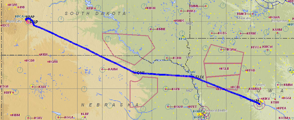
Flight 9: Des Moines, IA to Rapid City, SD
The weather improved drastically from yesterday’s gloominess. Today the sky was a bright clear blue. The time we took to prepare the plane yesterday made this morning’s departure very efficient. We were loaded up and calling for our IFR clearance within a few minutes.
The Des Moines ATIS said “Des Moines airport information Zulu, 1254Z. Wind 350 at 6, visibility 10, few clouds at 25,000, temperature 21, dew point 18, altimeter 29.99, landing and departing runway 31.” My shorthand notes for all that read: “Z 1254 350@6 V10 250FEW 21/18 A2999 RWY 31”.
My IFR clearance, “Mooney 201UT is cleared to the Rapid City airport via the Des Moines Five departure, then as filed. Climb and maintain 5,000 expect 6,000 ten minutes after departure. Departure frequency 123.9. Squawk 7050.” As usual, I used the CRAFT template to copy the clearance:
C RAP
R DSM 5 AF
A 5000 XP 6000/10
F 123.9
T 7050
I still get a chuckle out of reading “C RAP” in my handwritten notes. That transponder code (7050) was kind of strange. Transposing two of those digits would get us a lot of unwanted attention. To understand why, you can read this article about transponders. I actually called the controller back to verify that’s the code they wanted us to use.
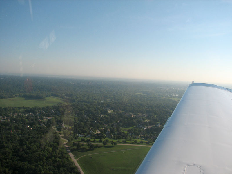

We climbed out into beautiful clear blue skies and soaked in the lush green scenery one more time before heading west to the high desert of Idaho. Flight conditions were ideal for our westward journey. We were enjoying blue skies with the sun at our back. An hour into the flight, we spotted Sioux City, Iowa and the winding Missouri River that marked the Nebraska border. After passing Sioux City, we made a slight left turn on a course of 271° towards our next checkpoint: O’Neill, Nebraska.
Winds Aloft
About 40 miles east of O’Neill ATC instructed us to climb to 8,000 feet so they could keep us in radar coverage. At our previous altitude of 6,000 feet our ground speed was 157 knots (181 mph) and after climbing to 8,000 our ground speed increased to 167 knots (192 mph). This was unusual since the prevailing winds are usually out of the west, so it would have been normal to get a strong headwind heading west. Instead we had a significant tailwind that was very different from what was forecast when I got my weather briefing earlier in the morning. I’m not one to complain about an unexpected tailwind, but the weather forecasters really like to know when the winds are doing something different than they expected. After using the E6B function of our 396 GPS, I determined the actual winds aloft were 165@54 (and they were forecast to be 350@9). I filed a pilot report with Flight Service to let them know about the conditions.
After passing O’Neill we turned right to track our new course of 291° which would take us directly to the Rapid City airport (KRAP). The flight plan that FliteStar calculated based on the forecast winds aloft said we’d need to fly a magnetic heading of 283° to track the 291° course. Since the winds were much stronger than forecast, we had to fly with a 30° crab angle: heading 261° to track the 291° course. The hefty 30° crab angle knocked our ground speed back down to 157 knots. That still wasn’t too bad for a westbound trip at 8,000 feet.
The terrain elevation began to climb as we continued towards Rapid City. The flat green views were gradually changing to a rolling desert brown as we scouted the horizon for the Black Hills With the higher terrain, ATC again instructed us to climb to stay in radar coverage. At this point we were 150 miles from Rapid City and our new assigned altitude was 10,000 feet. After completing the climb our ground speed was knocked down to 145 knots (167 mph) due to stronger winds.
When we were 100 miles from Rapid City, ATC asked if we could climb to 12,000 feet to remain in radar coverage. Apparently one of their radar sites was inoperative in the area, so they wanted us higher to keep us on their scopes. Climbing to 12,000 feet was certainly within the capabilities of the airplane but I didn’t want to lose another 10 knots of ground speed with the stronger winds that were sure to be waiting for us at 12,000 feet. We were in clear blue skies, so I offered to cancel IFR and just proceed to Rapid City VFR. The controller was really nice because he could have taken me up on that offer and had us out of his hair. Instead he simply invoked non-radar IFR procedures to let us remain on our IFR clearance. The controller instructed us to maintain 10,000 feet and to report 55 miles southeast of Rapid City. I created a GPS waypoint at the 55 mile point, and added that to our flight plan. This would help identify that location and give us a nice reminder to make the report.
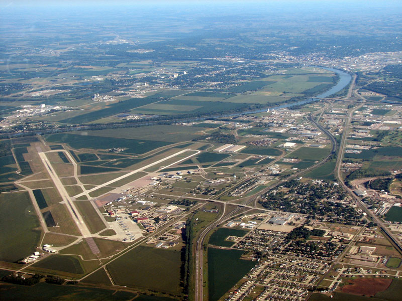
After making the requested report at 55 miles from Rapid City, we were handed off to Ellsworth Approach. This was an Air Force controller at Ellsworth Air Force Base, which was the home of the B-1 bomber we saw in Oshkosh (see bottom of part 4 of this trip journal). Ellsworth AFB is just north of the civilian Rapid City Airport. As we got closer to the airport, the approach controller said, “Report Ellsworth Air Force base and the Rapid City airport in sight.” With the two airports less than 5 miles apart, I’m sure there have been cases of people landing at the wrong airport. Landing a civilian aircraft at a military airport without authorization is a good way to meet lots of new and interesting people. We identified both airports and made sure we were heading for the one on the south side before making the requested report. The Ellsworth approach controller cleared us for the visual approach and handed us off to Rapid City Tower who gave us our landing clearance for runway 14.
The conditions were gusty and bumpy as we approached runway 14, but Phil still managed a great landing. I popped the door as soon as all three wheels were on the ground to cool down the cabin. It was immediately obvious that we were back in the dry heat and it felt GREAT! We taxied to West Jet Air Center for a fuel fill-up and weather check. Next stop Idaho!
Flight 10: Rapid City, SD to Idaho Falls, ID
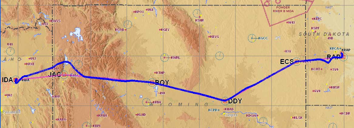
We were back in the Mountain time zone, and the local time was 10:45 am. The flight planning computer was down at the West Jet Air Center, so I had to get a weather update over the phone. I filed an IFR flight plan to the Idaho Falls airport (KIDA) via Newcastle (ECS), Muddy Mountain (DDY), Boysen Reservoir (BOY), and the Jackson (JAC) VORs. The dogleg to Muddy Mountain kept us closer to lower terrain enroute and gave us more airport options, while only adding 6 minutes to the flight time.
The weather was pretty good. There was a low in eastern Montana and high pressure in Wyoming and Idaho. There were no AIRMETs and the radar picture was clear with the exception of some light precipitation in southeastern Idaho. The forecast for Idaho Falls was for winds 330@4, visibility 10 miles and scattered clouds at 20,000 feet AGL. The area forecast for Idaho was for winds variable at 5 knots, scattered clouds at 10,000 MSL. The western Wyoming forecast was for scattered cirrus clouds at 15,000 MSL and widely scattered thunderstorms.
It would take just over 3 hours to fly to Idaho Falls from Rapid City, so we’d be landing around 2:30 pm local time. The forecast for widely scattered thunderstorms was typical for a summer afternoon in Wyoming and Idaho. I was glad to hear there was nothing significant on radar, but I was anxious to get in the air before the heat of the day started building up those thunderstorms.
After topping off the fuel tanks and eating a quick snack, we were ready to take to the sky again. Rapid City ground cleared us to “Idaho Falls as filed, climb and maintain 12,000, departure frequency 119.5, squawk 2722.” We departed runway 14 and began climbing out to the west.
Mount Rushmore

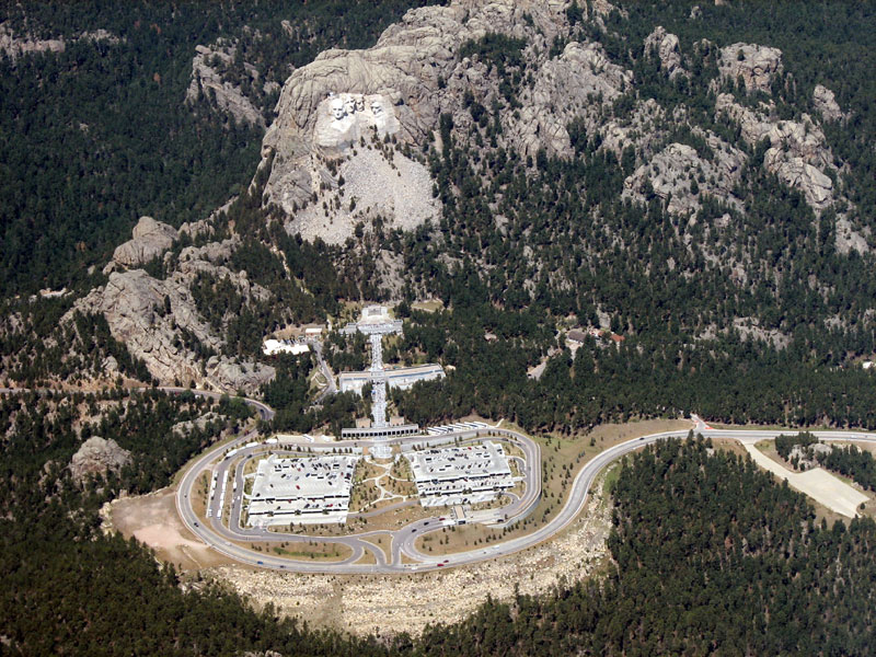
Now that we were on our way, we had a sightseeing detour we wanted to make before leaving South Dakota. The Mount Rushmore monument is located just southwest of Rapid City. Phil called Ellsworth Approach with our request to fly past the monument during our climb and they kindly obliged with radar vectors until we were able to spot the impressive carving.
The air was warm and bumpy which challenged me to zoom the camera in on the far away image. I was determined to get at least one good picture before our view was gone. Contrary to what Phil believes, there are times when a slower plane would be appreciated. I kept clicking away while Phil kept our flight on track. After a few minutes in the bumpy air, my stomach reminded me that it was time to take a break and just look outside. Phil took his turn with the camera while my stomach and I got back in motion mode. I definitely enjoyed our view from the air, but it was difficult to fully appreciate the monument in just a few minutes from a distance. We both agreed that an overnight stop was in our future for a closer look. We also want to check out the Crazy Horse Memorial which we just caught a quick glimpse of before we turned back on course to our first waypoint of Newcastle, WY.
Up Next: Homeward Bound
The next part will be about our cloudy flight around the Teton Mountains on our way home to Idaho.