Next Stop: Manassas, Virginia
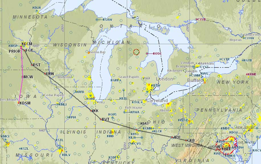
On Tuesday night, we planned our flight from Minneapolis, Minnesota to Manassas, Virginia with a fuel stop in Dayton, Ohio. This was a new route, since our original plan was to fly from Appleton, Wisconsin to Manassas, VA, but the airplane never made it to Appleton as planned. I chose Dayton as our fuel stop on the way to Manassas because it’s a fairly large airport that has good maintenance facilities available. Since we just had maintenance done on the Mooney, I was being extra-conservative in our flight planning. The chances were slim for us to have more mechanical problems during the trip, but I didn’t want to be stuck at a small airport with limited facilities just in case. We could reach Dayton in slightly over 3 hours, and Manassas would be another 2 hour flight from there.
I was doing all this flight planning with limited information, since our hotel room didn’t have internet access. So I used the good old fashioned telephone and called up Flight Service for an outlook briefing for the flights I had tentatively planned for the next day (Wednesday). The weather picture wasn’t good. There was low pressure at the western end of Lake Superior with a cold front stretching south through Illinois. That meant we’d probably be all right departing Minneapolis, but then we would likely run into weather problems closer to Dayton as we moved towards the cold front. Looking further east to Manassas, there was a stationary front in that area with low pressure along the eastern seaboard. If we didn’t like the weather going to Dayton, we could expect more of the same towards Manassas. That’s not the kind of weather I want to fly in, especially during our first flight after maintenance. When the briefer checked the NOTAM list, he saw that the Dayton airport would be closed for an airshow the day after next (Thursday). If for some reason we had to remain overnight in Dayton on Wednesday, we might have problems departing on Thursday due to the airshow. This plan wasn’t working. Time for a new one.
Next Stop: Manassas, Virginia Des Moines, Iowa

Even before the day heated up, thunderstorms were already stretching across the Iowa-Illinois border. You can see how we’ve got a clear shot to Des Moines (in south-central Iowa, marked with DSM on the map).
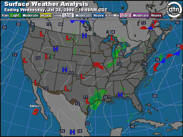
Given the forecast of bad weather to the east, we decided to fly south and stop for a night in Des Moines, Iowa. We chose Des Moines because it also had a good maintenance facility available (which we hopefully would not need), and it was well west of the cold front and associated bad weather. Making the short 80-minute hop from Minneapolis to Des Moines in nice weather seemed like a better choice for this first flight after maintenance. Moving south would also hopefully give us a better shot to make the flight to Manassas on Thursday, since the low pressure around Lake Superior was likely to hang around and cause more problems in the north. Spending the night in Des Moines would allow time for the weather to work its way through as well as a chance for us to recharge our batteries before reaching Washington, DC. We were both worn out from spending yesterday in the sun and then driving all afternoon–especially after moving from hotel to hotel for four nights.
Picking up the Mooney
On Wednesday morning, we grabbed a quick breakfast and excitedly drove to the Flying Cloud Airport to reunite with the Mooney. ASI Jet Center had the plane ready to go on time, and for the price they estimated for me on Monday. They had free wireless access available in their lobby, so I was able to use my tablet PC to get an online weather briefing and file our IFR flight plan to Des Moines. The current weather conditions matched the forecast I got the previous evening during my telephone briefing. A long line of thunderstorms stretched from the northern border of Illinois to the southwest along the Iowa-Illinois border. This was definitely not a good day to fly to Manassas, so our decision to fly to Des Moines was correct. The route between Flying Cloud and Des Moines was clear and we had no weather issues for our upcoming flight.
I continued to struggle with the high humidity as I loaded our belongings into the plane. Elliott Aviation was a huge help to us here in Flying Cloud. I was happy to learn that they also had an FBO in Des Moines. I made one phone call with our short notice request and they took care of our hotel and rental car arrangements. High-quality service from an FBO makes these unplanned detours so much less stressful. All the extra service we got from Elliott did not come with a big price premium. The only thing we had to pay for was fuel, and their fuel rates were pretty reasonable.
Flight 4: Flying Cloud, MN to Des Moines, IA
I always do an extra-thorough preflight inspection after the airplane has come out of maintenance. On occasion I’ve found tools left in the airplane, or access panels not secured. ASI Jet Center did a fine job with the airplane, and it passed my inspection. We got the cockpit organized, buckled in, and crossed our fingers before turning the key. Our new starter kicked the prop over immediately and we enjoyed the wonderful sound of our engine coming to life.
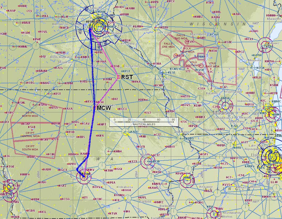
I contacted Flying Cloud ground to get our clearance to Des Moines. For such a short flight, I expected to just get cleared along my filed route: MCW V13 ANKEN, which was basically the most direct route along the airways. The clearance came back with a different route though, “Cleared to the Des Moines airport via radar vectors Rochester V161, then as filed. Climb and maintain 3,000. Expect 7,000 ten minutes after departure. Departure frequency 125.0, squawk 4571.” I wasn’t sure why they wanted us to make the little jog to the east over the Rochester VOR. Nancy programmed our cleared route into the GPS, which told us the ATC-assigned detour would only add 7 minutes to our estimated flight time.

When we contacted the departure controller shortly after take off, he gave us a vector of 180, which was pretty much straight on course to Des Moines — not towards the Rochester VOR as we were originally cleared. As you can see from our actual ground track, we ended up flying the route we originally filed even though our initial clearance was different.
The flight visibility started out great, but then dropped down to about 5 miles as we got further south. Five miles visibility is technically legal for VFR flight, but I was certainly glad to be on an IFR flight plan. It would have been challenging to try to navigate using ground references with the visibility this low.

Picture of the GPSmap 396 screen on the way to Des Moines. Sorry for the blurry image — the camera focused on its own reflection in the screen.
You can see that we’re about 19 minutes from the Mason City VOR (MCW), and that Des Moines (KDSM) is in the clear. On the left (east) side of the screen you can see the thunderstorms that kept us from attempting to fly to Manassas this day. Oh, and check out our ground speed in the top-left corner: 160 knots (184 mph).
A quick check of the weather display on our Garmin 396 showed that we were well clear of the line of thunderstorms off to our east. A picture says a thousand words, but the image I took of the 396 screen is blurry so I guess that’s only good for 500 words. It’s still a cool shot, and conveys the wealth of information we have available when the GPS has the weather overlaid right on the moving map.
When we got close enough to Des Moines to pick up the ATIS, they were reporting 6 miles visibility and were using runway 13. Again this was still legal VFR, so many airplanes were flying in on the visual approach. Since we were not familiar with the airport, I chose to fly in using the RNAV (GPS) RWY 13 approach. That way our IFR GPS would give us positive guidance right down the centerline of the runway. We were initially cleared direct WATTY, and then got vectored on to the final approach course. Being perfectly lined up with the runway sure makes it easier to spot the airport, and we had it in sight about 5 miles out.
We landed in Des Moines by early afternoon and Elliott Aviation had taken care of everything we asked them to do. We loaded up our rental car and quickly found our hotel just a few miles away. I was happy to have an afternoon without any plans. Our only goal was to relax. So we did.
We explored Des Moines briefly and then started to work on a draft of the web write up. Phil periodically checked the weather trying to predict if our route to Manassas would clear up by tomorrow. At this point, it looked like our stay in Des Moines would be brief.