More time in Washington, DC
When we originally planned this trip, we intended to visit New York City after our stop in Washington, DC. Shortly after arriving in Washington, we decided to spend an extra day in DC and skip the visit to New York City. We’ll save that for our next trip east. There were so many things to see and do in DC, and we didn’t want to rush ourselves. Also, we were both looking forward to the luxury of staying in the same hotel room for four consecutive nights after spending the last week bouncing from hotel to hotel.
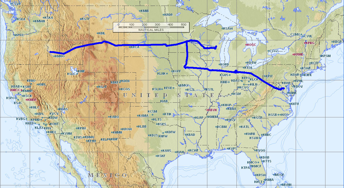
Look How Far We’ve Come
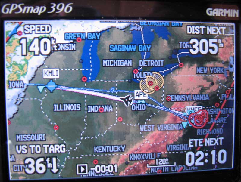
We’ve flown all the way from Boise, Idaho to Washington, DC and made our first visit to the EAA AirVenture in Oshkosh, Wisconsin along the way. The map here shows the territory we covered during our eastbound trip.
Manassas, Virginia
During our flight to Washington, DC we had quite a bit of late-afternoon thunderstorm activity to deal with. To help us avoid the worst of the weather, we decided to get an early morning start from the Manassas, Virginia airport and the best way to do that was to spend our last night in the DC area right in Manassas.
Manassas is only 30 miles from Washington, DC, and is a city rich in history (such as being the location of the first major land battle of the Civil War). Although we were just a few miles from DC, we could tell we were in the South. During the complimentary breakfast at our hotel, we got a charming Southern welcome. One of the hotel employees, in a lovely Virginia accent asked, “Did y’all get y’all’s kissy mints?” Kissy mints turned out to be a little box of breath mints that she was giving to each guest. We both loved her accent and the broad smile she delivered along with the kissy mints.
Flight 7: Manassas, VA to Des Moines, IA
Weather Briefing
I phoned in for a weather briefing for today’s flights. The plan was to fly from Manassas, Virginia to Des Moines, Iowa with a fuel stop in Huntington, Indiana. Huntington was very close to our previous Indiana fuel stop of Fort Wayne, but the fuel was much cheaper at Huntington. Factoring the forecast headwinds, it would take about 3.1 hours to get to Huntington, and then another 3.0 hours from there to reach Des Moines. The weather was generally good for both of the IFR flights we had planned. No precipitation was on the radar, but there were clouds and haze throughout most of the mid-Atlantic states. Western Maryland had fog and hazy conditions with visibility as low as 1-3/4 miles. The clouds were forecast to clear up around Ohio. A stationary front stretched along the western border of Iowa, which could affect our plan to reach Des Moines. We would have to check on the Des Moines conditions during our fuel stop, and be prepared to land elsewhere if the weather wasn’t favorable. Of course, with our Garmin 396 we could also get weather updates plotted right on our GPS screen while in flight.
Departing Manassas
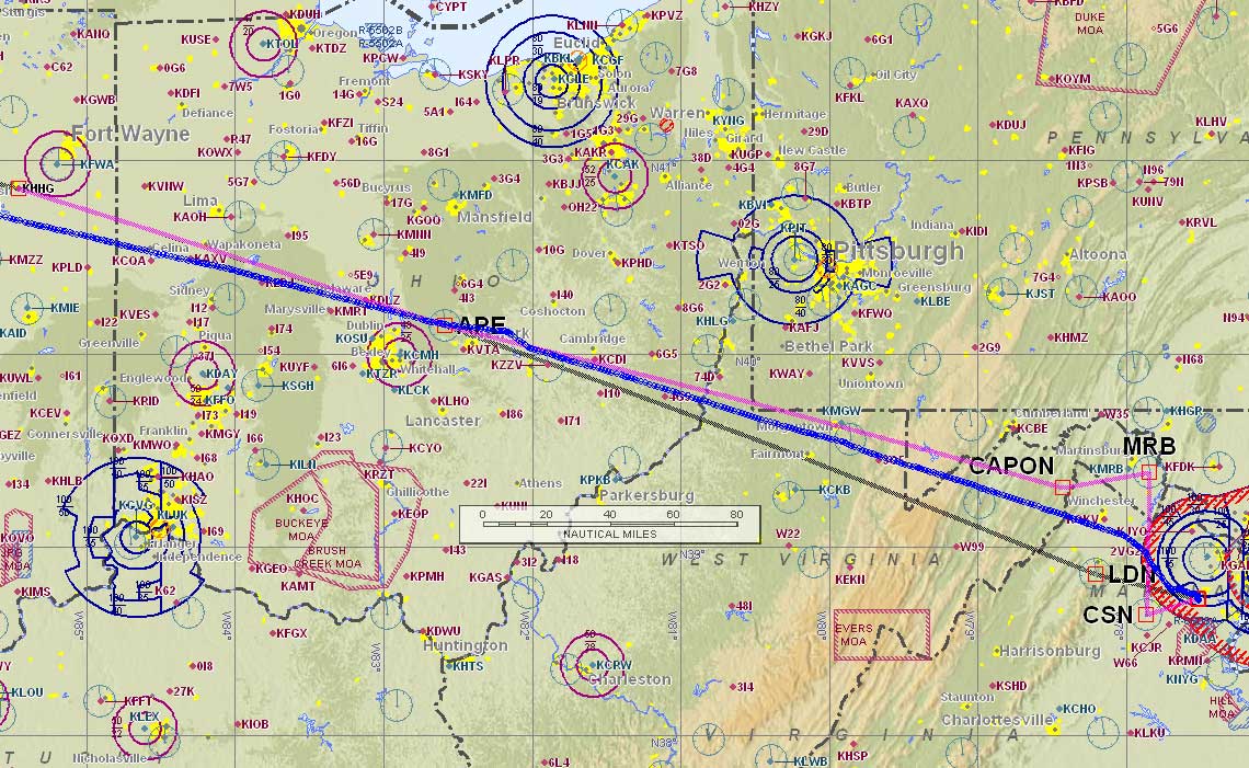
The gray line shows our original filed route. The magenta line shows the route we were originally cleared to fly, and the blue line shows the route we actually ended up flying (very close to the original filed route).
We settled up our bill with Dulles Aviation and got the plane loaded up. It was nice to be back into our routine of flying after four days of being ground-bound tourists. The new starter cranked the engine to life easily and we were soon getting our IFR clearance to Huntington. I had filed a fairly straight route to Huntington: direct Linden (LDN) direct Appleton (APE) direct, but that’s not the clearance I got. “Mooney 201UT is cleared to the HHG airport via the Arsenal One departure Martinsburg transition, V116, CAPON direct Appleton direct. Expect 8,000 ten minutes after departure. Departure frequency 124.65. Squawk 6253.” As usual, I copied the clearance using the CRAFT template:
C HHG
R ARSNL ONE.MRB V116 CAPON D→ APE D→
A 8000/10
F 124.65
T 6253
Flying the Arsenal One departure involved a lot of maneuvering around the DC airspace. Nancy and I both carefully reviewed the procedure before we advised we were ready for departure. We departed into hazy skies from runway 34R at Manassas, and a Cessna 152 had just departed runway 34L in front of us. We kept the 152 in sight as we climbed above her and passed her on the right.
Although we had carefully studied the Arsenal One departure, and programmed it into our GPS, we ended up not having to fly that departure procedure at all. Instead Potomac Approach just gave us radar vectors and shipped us off with a clearance directly to Appleton. The Potomac Approach controllers were great, and we did our part by paying close attention to their instructions. We had four radio frequency changes within 6 minutes — I think that was a new record for us.
Des Moines Weather Update
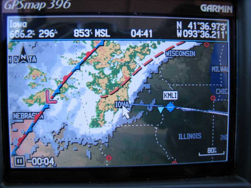
Shortly after clearing the busy airspace near Washington, DC I had a chance to pan the 396 display westward to see what the weather looked like in Des Moines (almost 700 miles away from our present position). There were lots of thunderstorms brewing all around Des Moines, and I figured those would just get more intense as the day progressed. I told Nancy, “There’s no way we’re going to make it to Des Moines today.” We made a tentative plan to stop in Moline, IL where the weather was clear. We chose Moline as our Plan B overnight destination because we stopped there during our 2003 trip across the country
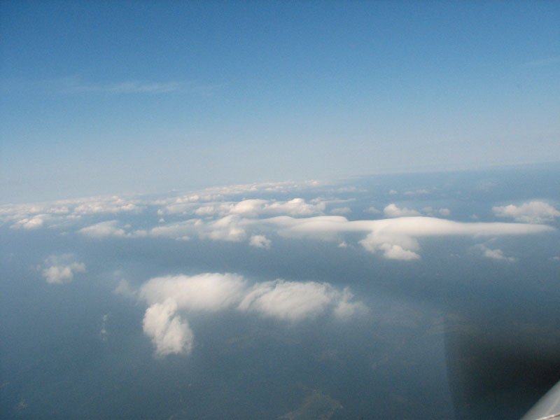
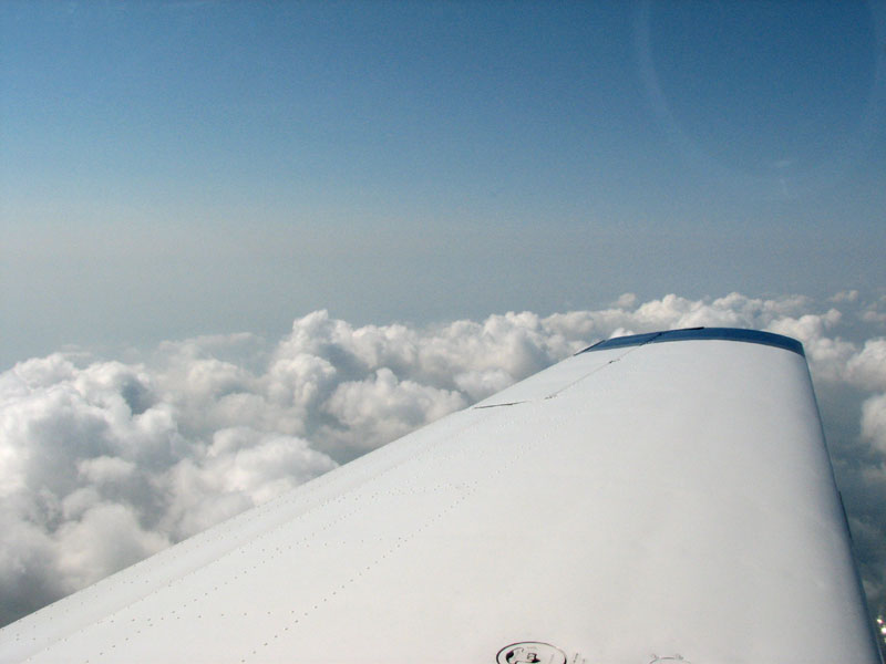
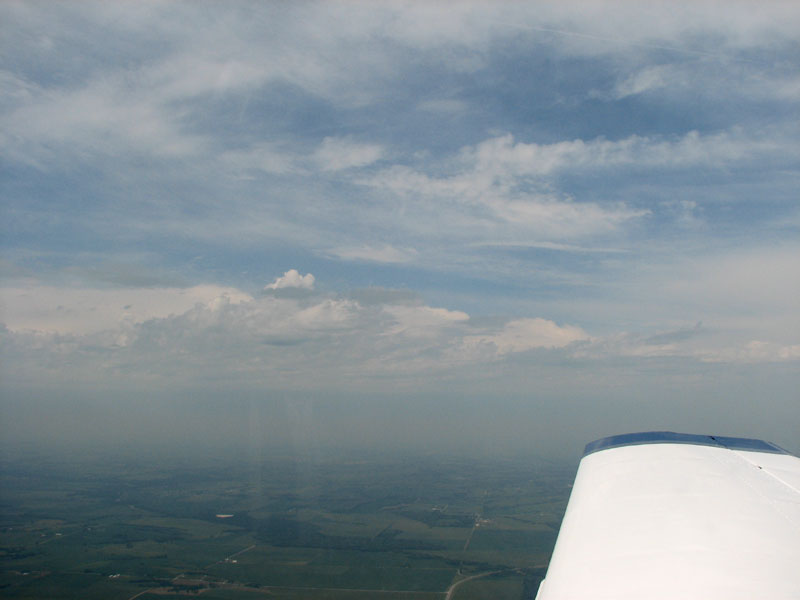
After checking the weather on the 396, we had a chance to take some pictures as we climbed above a scattered cloud layer to our planned cruising altitude of 8,000 feet. After clearing the cloud layer we were finally in clear skies and well above the hazy visibility below. It was a nice change to be flying west in the morning without the sun in our eyes.
Fuel Stop?
I started to wonder if we even needed to make the fuel stop in Huntington, IL. We were pretty sure we’d be staying overnight in Moline due to the stormy weather in Des Moines. Given that Moline was just an additional 230 NM (or 1.5 hours) west, it seemed unnecessary to make a fuel stop in Huntington. At this point, we’d been flying for an hour and the GPS reported that we could reach Moline in 4 more flying hours. The airplane had 6 hours of fuel when we departed Manassas. We could land in Moline and still have an hour’s worth of fuel remaining in the tanks.
There were several advantages to bypassing the fuel stop in Huntington. The biggest one was that we’d save time and be able to land in Moline earlier in the day. The earlier we could reach our destination, the better chance of avoiding the typical late afternoon thunderstorms. Another advantage to skipping our fuel stop would be to stay in the nice cool air at 8,000 feet. We knew that it would be hot and humid on the ground.
There was also one major issue with the long flight possibility — would our bladders be up to the 5 hour challenge? We were both quick to recall our game of bladder chicken and the unplanned stop in Needles, CA on a previous trip. We talked through all the advantages and concerns. With 4 flight hours to go, we both felt like we could make the trip comfortably. Our next touch down point would be Moline.
Cleared Direct Moline
Shortly after we passed the Appleton VOR in central Ohio we told ATC of our plans to land in Moline instead of Huntington, and we requested a descent from 8,000 feet to 6,000 feet (because we knew the headwind would be less at a lower altitude). Our request was quickly approved and we were cleared direct to our new destination at the new altitude. That was at 9:40 EDT and prior to our descent the GPS showed our ETA at Moline as 13:11 EDT and our ground speed was 141 knots (162 mph). After leveling off at 6,000 feet with the lower headwinds our new ETA was 13:08 EDT and we were traveling at 143 knots (165 mph) over the ground. The 2,000 foot altitude change only gave us 2 knots more ground speed which didn’t really make a significant difference in our arrival time at Moline. We did note that the lower altitude required a slightly higher fuel flow.
Where Are We?
Our airplane has an IFR-certified Garmin 430 GPS installed, so we’re perfectly legal using that as our only source of navigation information. I’ve also got our portable Garmin 396 GPS mounted on the yoke right in front of me, and that also plots our current location as well as the latest weather updates. Even with two independent GPS systems aboard, we’re still in the habit of cross-checking our position using ground-based navigation aids (such as VORs or NDBs. “Wikipedia entry on NDB”)
I tuned in the Peotone, IL (EON) VOR on frequency 113.2 and got a needle indication that did not make sense. Given our present position and course, I expected the course deviation needle to be close to centered with a “to” indication. Instead I saw a full-scale needle deflection and a “from” indication. When I tuned in the audio signal from the VOR, the Morse code identifier was not E-O-N. A while ago, I decided to learn Morse code just for this very reason — to be able to identify navigation station by listening to the Morse code, and not having to look at the map to match the dots and dashes printed there. I used the fantastic PilotMorse software to learn what all those dots and dashes meant. Being the competitive couple we are, Nancy decided to learn Morse code too. We both remembered enough Morse to know for sure we weren’t hearing E-O-N. The race was on to see who could decode what we were really hearing first. After listening to the code repeat a few times, I figured out it was S-G-H which is a VOR in Springfield, Ohio that is also on frequency 113.2 (and is about 200 nautical miles east of the Peotone VOR). This was a great example of why you should always identify a navigation aid using its Morse identifier before relying on the signal.
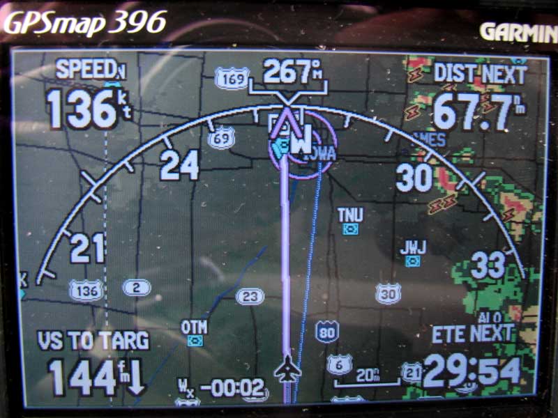
Another Des Moines Weather Update
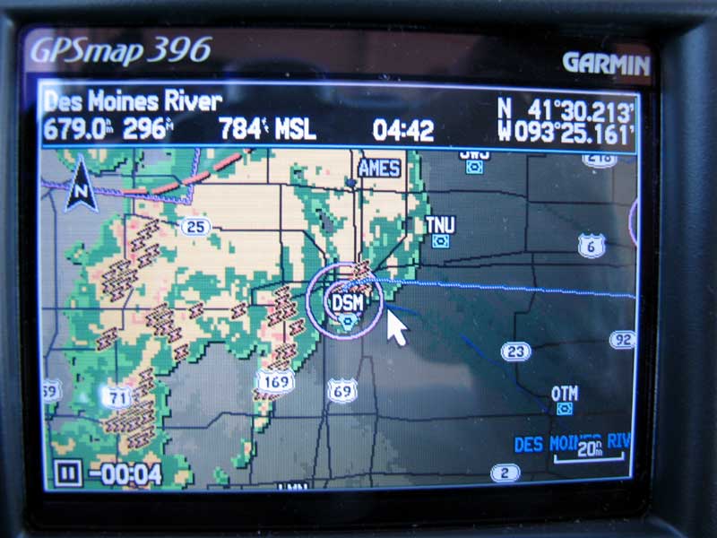
We periodically checked the weather in Des Moines while en route to Moline. I panned the 396 map west and saw that there were still thunderstorms in the Des Moines area, but the storms were moving to the north and the weather appeared to be clearing. In fact, right at the Des Moines airport the skies were clear.
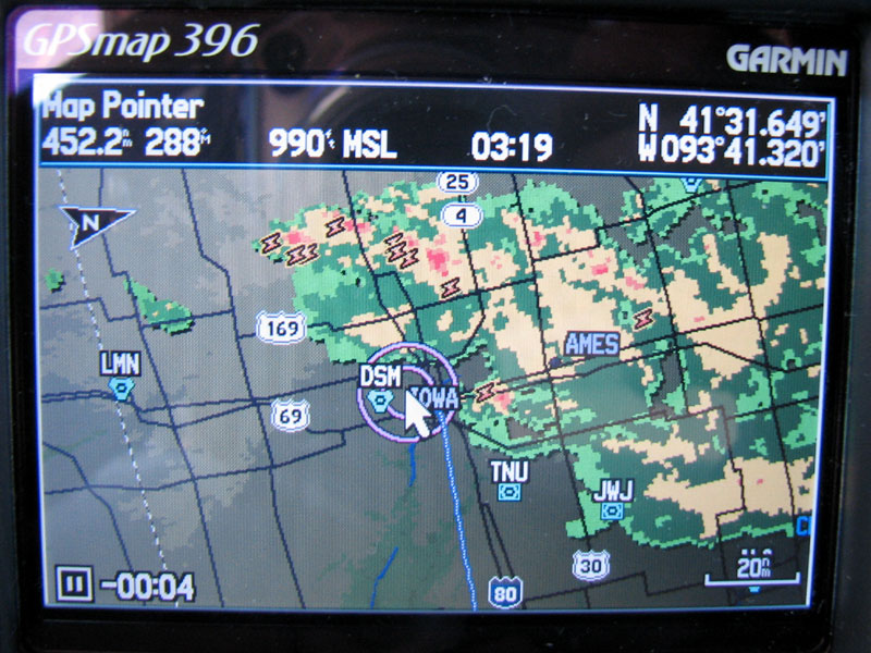
When I first looked at the weather in Des Moines earlier in the day, I was sure we’d be overnighting in Moline. Seeing the radar starting to clear up around Des Moines gave me hope that we might be able to make it there if the weather trend continued. I had assumed the morning thunderstorms we saw in Des Moines would just get worse as the temperatures rose in the afternoon. That didn’t appear to be the case. Of course, we’d check the weather again after landing in Moline before deciding to continue to Des Moines, but our hopes were raised at this point.
Running on Empty
This flight was definitely the longest leg we’ve ever flown in the Mooney. As we approached Moline, Phil and I were both attentively watching the fuel levels and reconfirming our calculations. Flying for 4.9 hours brought the fuel gauges closer to “E” than either of us was comfortable with. Now we know why God gave us 4 hour bladders. Even though we still had 30 minutes remaining in each tank, I was relieved when we spotted the Moline airport straight ahead. Landing with a one-hour fuel reserve sounds pretty conservative. It’s not, especially when the fuel is split evenly between the left and right tanks. Having 5 gallons remaining on each side just isn’t very comfortable. Some pilots deliberately run a tank all the way dry, reasoning that it’s better to have 10 gallons in one fuel tank than 5 gallons each in two tanks. I’ve never been comfortable with the idea of running a tank all the way dry, although after this flight I can see the advantages of doing so.
After this experience, I know that our future flights will not be more than 4 hours per leg. Not only is it challenging to sit in one position for that long while watching the fuel gauges getting so close to “E”, but hydration was also an issue. We had plenty of liquids on board, but we drank carefully to avoid the consequences of needing a pit stop. In retrospect, I don’t think we drank enough fluids to stay fully hydrated given the heat and humidity.
Arriving in Moline
After landing in Moline, we taxied to the Elliott Aviation ramp there. We’re probably starting to sound like an advertisement for Elliott Aviation, but once again we had great service from this Midwest chain of FBOs. Elliott has locations in Moline, Des Moines, Minneapolis and Omaha. During this trip we visited three of the four locations (all but Omaha) and each time we were treated like VIPs who had just disembarked from a corporate jet. The staff was friendly and competent, the fuel prices were reasonable, and the facilities were clean, inviting and functional. For the record, we’re not affiliated with Elliott Aviation in any way — we’re just very satisfied customers.
Next Stop: Des Moines
While the Mooney was getting refueled, we confirmed that the weather did improve in Des Moines. The storms we were watching had in fact moved off to the north, so we decided we’d continue our journey westward. After the one-hour flight to Des Moines, we’d begin resting up for tomorrow’s long trek home.
Flight 8: Moline, IL to Des Moines, IA
We had just left Des Moines five days ago, so our second visit seemed like a homecoming. After so many new sights in Washington DC it was nice to see some familiar surroundings. By this time we were close enough to Des Moines to see with our own eyes what the radar images had been telling us: the storms had moved off to the north.
Phil graced the runway with an impressive crosswind landing and quickly taxied to Elliott Aviation. The winds were 200@13, giving us about a 7 knot crosswind component for landing on runway 23. Once again, the Elliott crew had our rental car, hotel reservation and dinner recommendations waiting for us. Did I already mention we’re big fans of Elliott Aviation? The lineman who helped us park told me that we missed some “really big thunderstorms” that rolled through in the morning. I nodded with a smile and let him know we had been watching those storms all day.
After 11 days traveling, all the rental cars are starting to look the same. It’s getting tough to remember what our rental car looks like, what our room number is, what time zone we’re in and even what day it is. As confusing as it seemed, I loved every minute of it. I’m so lucky to be married to my best friend, co-pilot, and fellow travel nut.
More storms are forecast for tomorrow. We’re planning to fly all the way home to Boise, but we’re also ready to cancel if the weather doesn’t cooperate.