Next Stop – Monterey, CA
We did some initial weather checking last night and made a general plan to head further south in California. We picked Monterey as our next stop on this flying honeymoon.
The Plan
Our host from the B&B, Don, was kind enough to give us a ride from Eureka to Kneeland for our noon departure. We had a great time at the Samoa Airport B&B, and plan to visit again. Don even stuck around to make sure we got the plane started OK, and had no problems taking off.

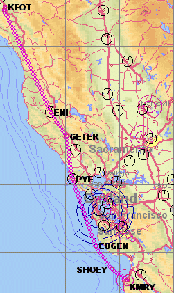
Since the low level fog was still lingering around, we planned to fly IFR from Kneeland to Monterey. Based on the forecast, we’d actually be in the clear for most of the trip, but would need to descend through a thin coastal fog layer to get into Monterey. There is no fuel available at Kneeland, so we made a quick 5-minute VFR flight to Rohnerville (FOT) to top off the tanks before starting the 2 hour IFR flight to Monterey.
The Flight
Rohnerville has no control tower, but we were able to contact Seattle Air Traffic Control from the ground. We opened our IFR flight plan with them and were given a 10-minute window to takeoff after our initial contact. Fortunately we were ready to go before we called.
We had great views of the California coastline, and the fog gently hugging the shore. It was really fun to fly over the same Redwood forests we had toured on the ground the previous day.
Nancy and I had flown around the Bay Area several times before under visual flight rules (VFR). Controllers provide traffic advisories to VFR flights when they have time available to do so, but their top priority is controlling aircraft operating under instrument flight rules (IFR). During our previous VFR flights, the controllers were very nice but when they got busy they had to drop us from their radar service. This was our first IFR flight through the busy Bay Area corridor and it was surprisingly easy. The controllers were extremely competent and friendly, and we had absolutely no problems sharing the same airspace as the hundreds of commercial planes in the area. The radio was actually quiet for most of the flight, and we both agreed flying IFR in this area was much easier than VFR.
We enjoyed wonderful views of downtown San Francisco, the Golden Gate Bridge, and the San Francisco Bay as we cruised in the smooth air.
When we got closer to Monterey, there were a few scattered clouds over the airport and a coastal fog layer covering most of the Monterey Bay. The controller asked which of the several instrument approaches to the airport we would prefer. This was a bit of a surprise — we were expecting them to assign a specific approach to fit us in with the rest of the traffic. As Nancy and I pondered the controller’s question, he quickly suggested “you could do the ILS 10R with a circle-to-land on 28L.” That was actually the easiest approach for us to do from our position, so we told him that sounded good to us.
Nancy has flown with me during practice instrument approaches on clear days, but this would be the first time that she would be with me during an instrument approach through actual clouds. We spent some time the previous night reviewing how to read the instrument approach charts, and what to expect as we got into Monterey. This paid off because Nancy was able to cross-check me while I was flying the specified approach procedure. Later, Nancy talked about how cool it was to see us slowly entering the clouds with a front-seat view. We’ve all seen this as passengers on jets looking out the side windows, but the view is really much better out the front. The cloud time was surprisingly peaceful. I was focused on watching Phil and making sure he stayed on track. Phil remained very relaxed and calm in the clouds. I must confess … from a non-instrument-rated pilot’s point of view, I found the coastline and city of Monterey a welcome site.
We landed and taxied to Million Air, where we got the red carpet treatment (literally!). They helped us find a hotel, and had a rental car available for us.
After checking in, we headed into town and had a great Indian dinner which we walked off by wandering around the waterfront and Cannery Row. We watched the sunset over the bay from a nice quiet spot. The actual name is Lovers’ Point, but Phil is to shy to say so.