The Plan
For the loop around the Western US, our only pre-planned stop is Eureka, CA (O33) and we have reservations at the Samoa Airport Bed & Breakfast, which is a WW II training base that’s been beautifully converted. After Eureka, we’re going to play things by ear and pick destinations based on the weather and the stack of Pilot Getaways magazines we’ve packed along. Pilot Getaways is how we found out about the fly-in Bed & Breakfast at Eureka.
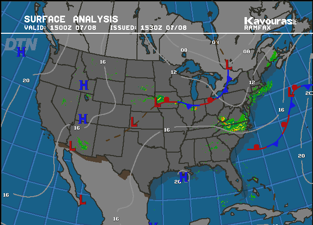
The picture here shows the current weather at 1500 GMT (9am MDT) on the morning of our departure. High pressure dominates, and it’s pretty clear for the whole route. There’s coastal fog in CA that’s forecast to lift around 3pm PDT.

The map on the right shows our planned route and the estimated flight time is 2:30.
The Flight

We departed Boise into beautiful clear skies and no turbulence. Along the way we traversed southern Oregon and watched the terrain change from desert to rolling green hills to the steep terrain as we passed by just north of Mount Shasta.
As we got closer to California, we found that the morning fog had lifted but the evening fog was already forming.
This meant it was time to start thinking about our options. We had over 2.5 hours of fuel remaining, so there was lots of time to figure out a plan. If needed, we could fly well into interior California for an alternate landing site.

Plan A:
Our planned destination (Eureka Muni – O33) does not have any instrument approaches to the runway, which means if you can’t see the runway then you can’t land there. We could see from the air the Eureka was completely fogged in. Nearby Arcata (KACV) has several instrument approaches, including an ILS so that seemed like a good plan.
Time for Plan B:
Then, we got the weather report for KACV from ATC. 100 foot ceilings and horizontal runway visibility (RVR) that was varying between 1000 feet and 2000 feet. The fog was too dense and low to try an instrument approach there. Time for plan C. The B&B we are heading for is owned by two pilots: Don & Shauna. When I spoke to Shauna on the phone, she suggested that if Eureka Muni was fogged in, we may be able to land at Murray (KEKA) and they’d pick us up from there.
How about Plan C:
We punched Murray into the GPS and started heading for it. When we were less than 3 miles from the airport and couldn’t see anything but fog, we realized it’s time for a new plan. Murray does have an instrument approach also, but it is a VOR approach which requires even higher ceilings and visibility than the ILS we didn’t attempt at Arcata. Eureka, Murray and Arcata are right on the coast and at sea level so they were all equally fogged in. Nearby Kneeland (O19) is a good alternate because the airport sits at 2737 feet MSL, which is usually well above the fog.

A few more button presses on the GPS and we found the tiny strip. It’s a pretty neat airport, that’s up on a plateau, and sure enough it was above the fog layer. The approach was a bit tricky to the short and narrow field, with a little hill that seems to be in the way (but it’s not) as you are trying to line up for the landing.
We called Shauna and Don after we landed and asked what we should do. We were expecting to get the phone number for a nearby taxi company, but instead they told us they would be right over. The straight-line flying distance between Eureka and Kneeland is only 13 NM (less than 5 flight minutes). Because of the curvy mountain roads, it takes about an hour to drive from Eureka to Kneeland.
Our hosts arrived right on time, got us settled in, gave us a car to use and recommended a good dinner spot. Tomorrow we’ll tour around the area from the ground to check out the magnificent redwood forests we flew over.
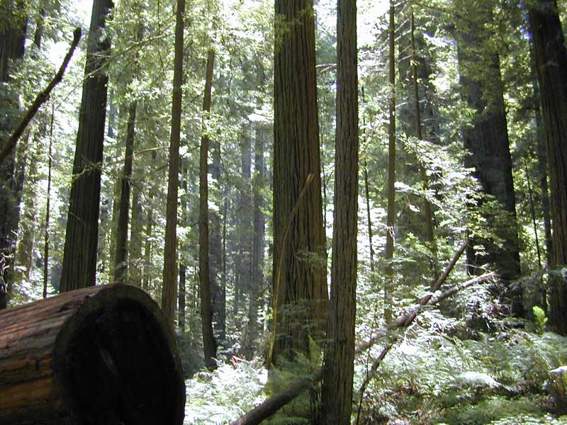
Touring the Redwoods
After a great breakfast prepared by Don, we set off to explore the famous giant redwoods south of Eureka. We drove down the “Avenue of the Giants” which winds through the dense forest, and stopped several times to hike and take some pictures. It was a great day getting in touch with nature and admiring the awesome redwood forests. You really need to see them to appreciate them, I don’t think we can write enough to do them justice, and the pictures below just barely give a glimpse of how large the trees are.