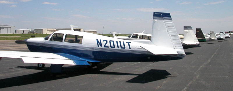
Mooney Mountain Flying Course
The Mooney Aircraft Pilots Association Safety Foundation conducts several training courses each year. I attended their Pilot Proficiency Program (PPP) in 1999 and learned a great deal there, so in 2004 I thought it would be good to go back for more refresher training and learn more about flying in the mountains. For the July training in Denver they conducted a Pilot Proficiency Program and a Mountain Flying Course. The two course tracks were divided for some of the training, but we all attended the general Mooney ground training together.
Since we live in Boise, we’re not exactly strangers to the techniques of mountain flying but this was a great opportunity to get some Mooney-specific training, fly in the Rocky Mountains, and spend a few days in Denver. Mooneys are not the best back-country airplanes since they have very short, stiff landing gear and the propeller doesn’t have much ground clearance. Some people do fly Mooneys into rough strips, but our airplane goes strictly to hard-surfaced runways. This Mountain Flying course concentrates on the techniques of flying near mountains using paved runways.
Ground Training
When I first saw the agenda for a full day of classroom instruction on Friday, I kind of rolled my eyes and figured I’d have to endure that in order to get to the good stuff — flying in the mountains. However the classroom instruction was well worth the time, and really was necessary before we headed into the mountains to put the theory into practice.
Cleon Biter led the Mountain Flying portion of the training. Cleon is a flight instructor, holds a Ph.D. in Meterology, and is a very experienced mountain pilot based near Denver. We talked about the operational considerations of flying in the mountains including density altitude, planning, starting, taxiing, runups, climb out, enroute, descent and landing. Cleon’s knowledge and presentation skills were outstanding. Later in the day we joined up with the folks enrolled in the PPP for classes on Mooney maintenance, accidents, aircraft systems, and operating tips. All the instructors were highly experienced, enthusiastic about Mooneys, and had lots of good information to share with us. They had no easy task as their audience was made up of pilots with widely varying experience levels who were flying airplanes that were anywhere from 40 years old to virtually new.
Flight Training
Each instructor was assigned two students, and for the mountain pilots the plan was to have each pilot fly in the morning either on Saturday or Sunday, and attend more ground training while not flying. It’s generally a bad idea to fly in the Rocky Mountains between noon and early evening since the density altitude is very high and thunderstorms are common. The other pilot who was assigned to my instructor needed to depart on Sunday morning, so we agreed he would get the Saturday morning slot. The course was scheduled to finish by noon on Sunday, but Nancy and I had already planned to spend Sunday night in Denver. We didn’t want to attempt to go west across the Rockies in the afternoon, so our plan was to leave early Monday morning.
As I headed into my ground training on Saturday morning, a scattered layer of clouds covered the Rockies. It was good enough to fly, but not great conditions. The folks who flew on Saturday got rained on a bit, and had some turbulence to endure. For my flight on Sunday morning the weather was absolutely perfect. There was virtually no wind, the skies were cloud free, and the temperature was a bit cooler than it was on Saturday. I was so glad that I let the other pilot fly first.
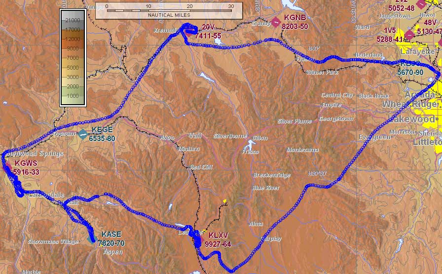
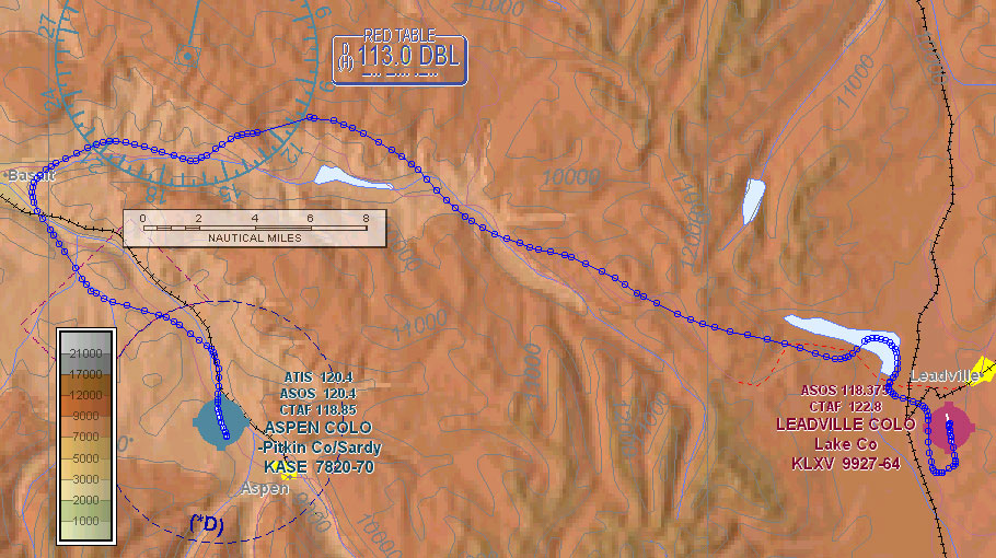
Bart Jones, the President of the Colorado Pilots Association, was my instructor for the flying portion of the course. He selected a route that would give us a good flavor of what it’s like to fly in the Rocky Mountains. Departing Jeffco, we’d fly almost straight west to Kremmling, then to Glenwood Springs, Aspen and then to the highest airport in North America: Leadville (elevation 9,927 feet). Our actual flying track is shown in blue on the maps on this page.
This is the same course the Colorado Pilots Association uses for their own Mountain Flying course and there was good reasoning involved in choosing this route. I’ll explain the reasoning as I describe each portion of the flight.
Jeffco to Kremmling
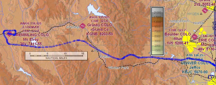
The path from Jeffco (BJC) to Kremmling (20V) goes through very wide mountain passes to give a gentle introduction to flying in the mountains. The first pass we go through after departing Jeffco to the west is relatively low and wide — there are even railroad tracks going through the pass. There are a few hills around Kremmling that put the airport out of view during portions of the landing approach. Bart explained that its common to not be able to see a mountain airport during the entire approach to land.
The airport and city were easy to see as we flew west towards the Willams Fork Reservoir, but the airport disappeared behind a ridgeline as we continued west towards the airport. After making a right crosswind for 27 (angled a bit west to avoid the town), the airport came into view again and stayed in view through most of the downwind leg. Just after we passed the touchdown point on downwind, a small hill hid the airport again and continued to block our view of the runway during almost the entire base leg. This meant I had to have a mental picture of where the runway was during the part of the approach where I would normally be fine-tuning my flight path to the runway.
The airport sits fairly high (about 7,400 feet) but it’s a long runway with a clear path should a go-around be necessary. Kremmling is a good place for the instructor to evaluate the pilot’s ability to make a short-field landing, and do additional practice if needed. This is important because the next stop, Glenwood Springs, is a more challenging short runway with terrain obstructing the approach and go-around paths. At Kremmling, I managed to nail the right speed (77 mph) on final for our landing weight (2,400 lbs) and we were stopped within 1,000 feet of the threshold. Bart let me know he liked that landing, and that I should plan to do the same thing at Glenwood Springs.
Kremmling to Glenwood Springs
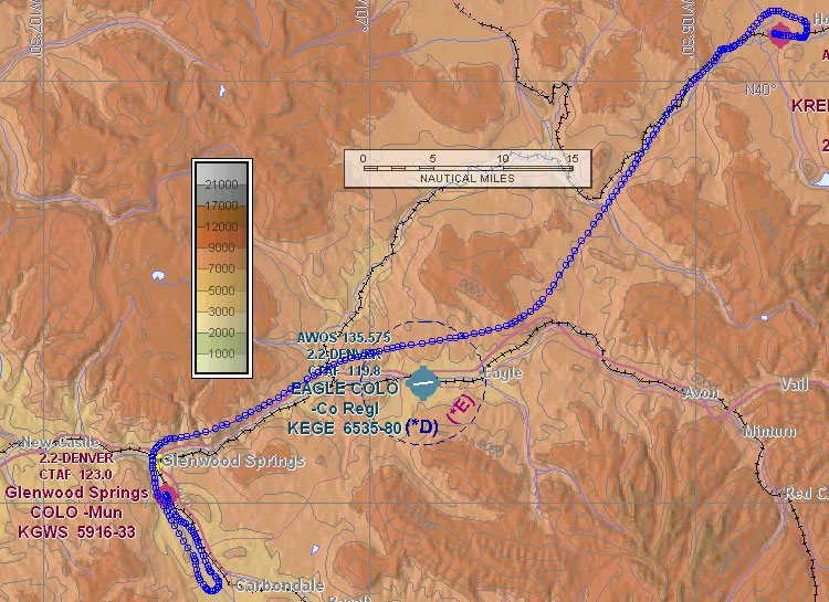
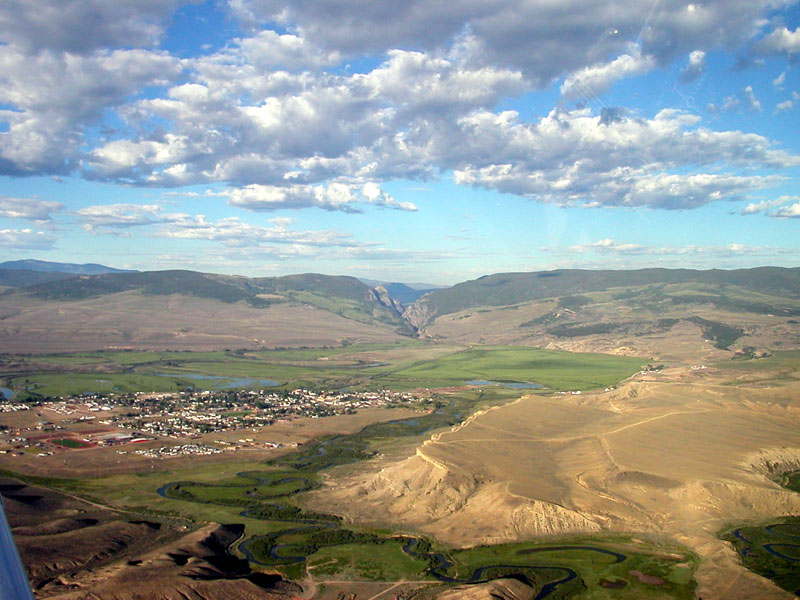
Glenwood Springs (GWS) is a small airport that sits in a narrow valley. After a left downwind departure from runway 9 at Kremmling, we flew heading 205 and climbed to 12,500 following the Colorado River through a canyon towards the Eagle airport. Then we turned right to follow I-70 from Eagle towards the city of Glenwood Springs. As the city came into view, the terrain drops and we started a descent out of 12,500. In order to make it down to the airport elevation of 5,916, we followed the valley southeast to Carbondale and took a look at the airport as we overflew it. By the time we were at Carbondale, our altitude was down to 8,500 which was just right for the 7 miles remaining to get back to Glenwood Springs.
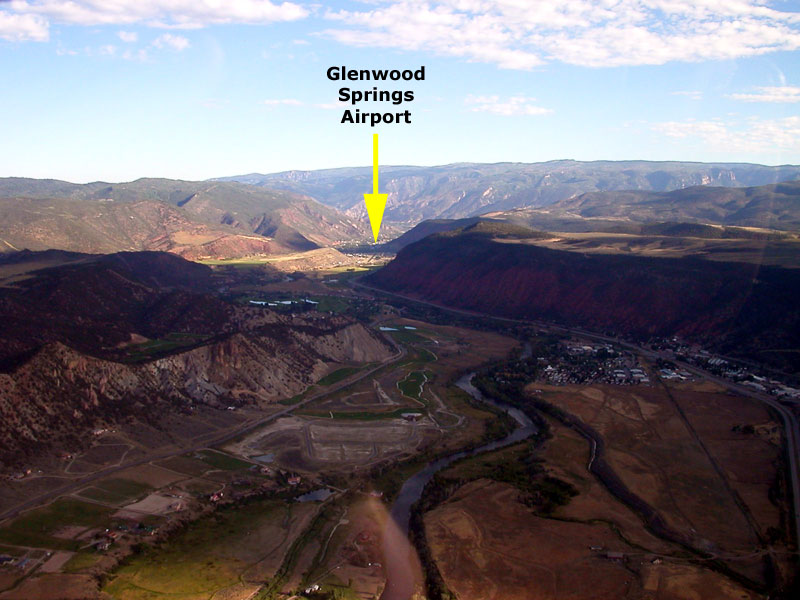
To avoid bothering some noise-sensitive neighbors, we had to fly close to the right (east) side of the valley, which again put the runway out of view. If you look at the larger view of our final approach track, can see how we paralleled the road (visible on the right side of the picture) for quite a while before coming back left to line up with the runway. As we were coming in to Glenwood Springs, a Cirrus pilot announced he was descending out of 10,000 near Carbondale. As typical for a non-towered airport, we talked with him and coordinated that we would land first since we were well ahead of the Cirrus pilot. I completed the challenging approach and landing with no problems, and we taxied to the end of runway 32 and waited in the turn-around area for the Cirrus pilot to land.
Glenwood Springs to Aspen
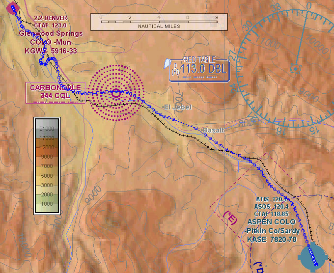
After Glenwood Springs’ small, quiet, non-towered airport we were off to Aspen to mix it in with the jets at a tower-controlled airport. Aspen’s airport (ASE) is very similar to Sun Valley, Idaho although I think Aspen is a little busier. Both airports are in a valley and have one way in and one way out.
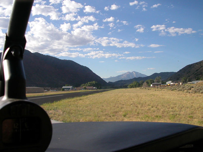
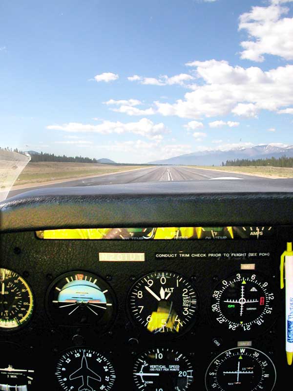
We departed straight out from Glenwood Springs runway 14 using a short-field takeoff to clear the trees and hills near the end of the runway (see picture below). We headed down the valley climbed to 9,500 and called Aspen at Basalt. We were quickly cleared to land straight in on runway 15. One jet was on the approach behind us, and we heard another jet getting a clearance to depart Aspen direct to Ft. Lauderdale, Florida. Landing at Aspen was quite easy, and the controller directed us to turn off then hold short of runway 33 for prior to departure.
Once the jet behind us landed, we were cleared to take off on 33 and were instructed to remain west of the river to stay out of the way of two jets on their way into Aspen. Yes, Aspen is definitely busier than Sun Valley. The controllers did a great job, and treated us just the same as the multi-million dollar jets sharing the skies with us.
Aspen to Leadville
As I mentioned earlier at almost 10,000 feet above sea level, Leadville (LXV) is the highest airport in North America. The airport elevation is higher than most aircraft in the flatlands fly during cruise. After departing Aspen, we headed back to Basalt then turned east towards Ruedi Reservoir as we climbed to 13,500 to make it through Hagerman Pass which is just southwest of the L-shaped Turquoise Lake. After clearing the terrain at Hagerman Pass we made a few turns to lose altitude before making a 45-degree entry to the left downwind for runway 34.
Landing on Leadville’s 6,400 foot runway was quite easy. It was only 8:30am, so even on this July day the temperature wasn’t that high so density altitude didn’t present much of a problem.
For this stop we decided to shut down and visit with the airport owners Dan & Xiangying Jensen. There was free coffee, cookies and cake available as we stretched our legs and just hung out for a little while. Dan filled out a nice “Certificate of Pilotage” documenting the fact that I landed at this famous airport. In addition to being the highest airport in North America, Leadville sits near the highest mountain in the Rockies: Mount Elbert (which is just a little higher than its more boastfully named neighbor Mount Massive).
We were the first of the group of Mooney Mountain pilots to arrive. Just as we were ready to head back to the aircraft, two other Mooneys arrived. We thanked our hosts for their hospitality, washed down the delicious cake with some coffee and headed out to the airplane as we discussed our plan to do a left downwind departure from runway 34. At this high altitude, we used a good chunk of the runway before the wheels came off the ground. I then stayed down in ground effect to help the plane accelerate to its best-rate-of-climb speed, and we started a nice climb before reaching the far end of the runway. Although there are lots of big mountains around Leadville, the terrain past the departure end of runway 34 quickly slopes down which makes the takeoff a lot less risky. I pulled up the landing gear and flaps and we started to make our way back to Jeffco.
Leadville to Jeffco
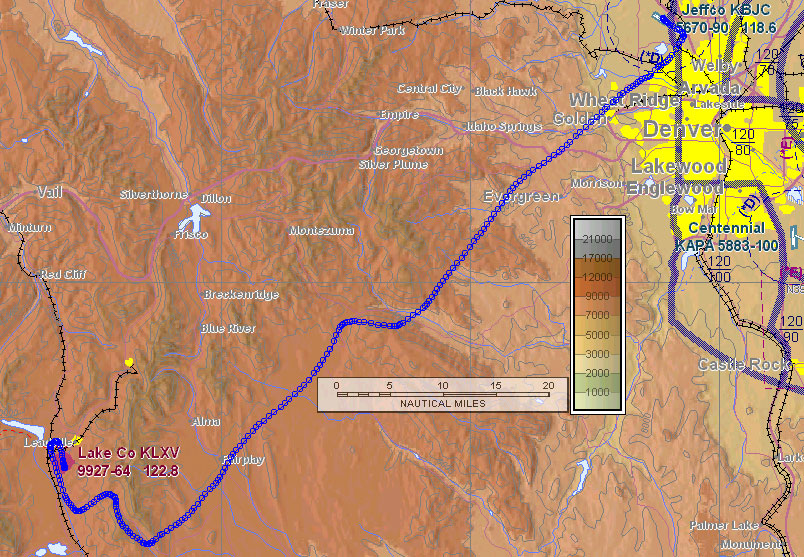
We did the left downwind departure from Leadville and began climbing as we looked for Weston Pass. The sun was beginning to heat up the mountainsides and we caught some nice thermals which gave us a nice thousand-foot-per-minute ride up to almost 14,000 feet to clear the pass. After Weston Pass we followed highway 285 through Kenosha Pass, then the valley of the South Platte River to the low ground (only 8,500) leading towards Jeffco. Denver Approach didn’t seem very busy when we called. They quickly gave us a transponder code and cleared us to descend through the Denver Class B airspace into Jeffco. When we reported the Jeffco airport in sight, we were switched to the tower controller who sequenced us in with the 4 or 5 other planes taking off and landing there.
Whew!
What a wonderful experience, and I was quite fortunate to have Bart Jones as my instructor and tour guide. His knowledge of the mountains, passes, and flying techniques was superb. Plus he’s a really nice guy and was fun to fly with. Bart was also wise enough to suggest a 5:30am start to keep us flying during the coolest part of the day, before the thunderstorms and density altitude had a chance to build up. We were done flying by 10:30am and the only turbulence we felt was a few bumps as we approached Jeffco. After learning more about flying through the passes in the Rockies, I decided to take a more direct route back to Boise but you can read more about that in the next part.