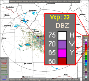
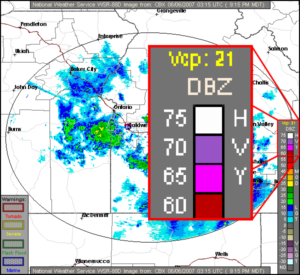
On one particularly beautiful Saturday morning, in preparation for a local flight with a student, I obtained most of my weather information by just looking out the window. The sun had risen above the peaks to the east and the sky was bright blue canvas devoid of clouds. The large American flag that I use for my visual wind check was relaxing against the flag pole. Today would be a great morning to fly, and perfect conditions for my soon-to-solo student. When I checked the weather radar image on ADDS, I was surprised to find lots of activity on the display. That couldn’t be right — radar only shows precipitation, and there wasn’t a cloud in the sky. What was going on?

Before calling flight service or logging into DUATS for a standard weather briefing, I usually visit the National Weather Service’s excellent ADDS (Aviation Digital Data Service) site. It’s a great site that gives access to all kinds of aviation weather information. At a minimum, I’ll take a look at the latest set of weather charts and the current weather radar. ADDS does not provide NOTAM information, so it’s not a substitute for getting a standard weather briefing from flight service or DUATs, but I wrote about that already.
Weather Radar Modes
Fortunately, the National Weather Service radar site has an great page called How Radar Works which led me to a page about Volume Coverage Patterns that explained what I was seeing. According to the VCP page, radar has two main modes of operation: clear air mode and precipitation mode. Precipitation mode is the one we normally see when there is, well, precipitation activity. Clear air mode is used when there is no precipitation and it’s the one that can surprise you if you don’t read the fine print. In clear air mode the radar is turned up to a very high level of sensitivity, and shows very fine particles in the air like dust and insects. That’s why I was seeing activity on the radar display on that blue sky morning.


The Fine Print
In order to tell whether the radar is operating in clear air mode or precipitation mode, you’ve got to look at the intensity scale to see which VCP mode is in use (VCP is described in detail on the VCP page I referenced earlier). There are many different VCP modes, but only thing you need to remember is that codes in the 30-39 range indicate Clear Air Mode. If you see “Vcp: 31” or “Vcp: 32” or “Vcp: 35” then you know the radar is in clear air mode, and the colors you are seeing on the display are not precipitation. Any other codes besides the thirty-somethings indicate that the radar is in precipitation mode and the colors represent the intensity of the precipitation.
XM Weather
Good news for XM Weather users (like those with the Garmin 396 or 496). As far as I can tell, XM Weather correctly filters out any radar sites that are in clear air mode. When the XM Weather display shows something on radar, it really is precipitation.
Text Radar Report
With all the graphic radar available, does anyone even bother with the old text radar report? The “Radar Report” (sometimes called “Radar Summaries”) is one item on a long list you’ll get from a DUATs weather briefing. I suspect I’m like most pilots, and I just skip over that text radar report since it’s much easier to see a graphical radar image like the ones available at ADDS.
However, the flight planning program that I use Jeppesen FliteStar does look at the text radar report and by default FliteStar overlays the radar returns on the flight planning map. This is generally very helpful, except that the text radar report doesn’t know about the clear air mode of the weather radar system. Here’s the text radar report for the same time as the clear air mode radar image at the top of this page.
Raw format: CBX 1235 CELL TRWX 140/7 D3 AREA 6R 272/19 87/10 34W AUTO ^LL2 ML15
Decoded: CBX (BOISE, ID) RADAR WEATHER REPORT AT 1235 UTC
A CELL OF ECHOES OF THUNDERSTORMS AND INTENSE RAIN SHOWERS 140 DEGREES, 7 NM 3 MILES IN DIAMETER
AN AREA OF ECHOES 6 TENTHS COVERAGE OF RAIN
272 DEGREES, 19 NM
87 DEGREES, 10 NM
34 MILES IN WIDTH
REMARKS:AUTO ^LL2 ML15

Wow, that sounds pretty serious: “a cell of echoes of thunderstorms and intense rain.” But I’m looking out at clear skies, so I know that’s bogus. Apparently whatever computer generates the text radar report doesn’t know about clear air mode. The screen shot to the right shows how FliteStar plots the results of the text radar report, which gives a very misleading picture of the weather.
The “thunderstorm and intense rain showers” are the red circle south of the Boise VOR. The large green area shows the “area of echoes 6 tenths coverage of rain.” Again, that’s all untrue since the radar was in clear air mode. The sky was clear bright blue — no thunderstorms or rain anywhere.
Fortunately FliteStar has an option to turn off the text mode radar plot. You can also overlay the graphic radar image instead, but you still need to know whether the radar is in clear air mode or not.
Bottom Line
When looking at a radar image, be sure you know how to tell whether the radar is in clear air mode or not. If it is in clear air mode (VCP 31, 32 or 35), then don’t worry about the returns shown on the radar display.
Phil and Nancy,
Good to be reading your posts again! Good info on the ADDS wx page. I use that and http://www.vansairforce.net/weather.htm along with DUATS on the AOPA flight planner.
Temps in the 90’s this week so no landing practice for me as previously planned. Mary and I will try to get in the air next week and hit KTGI. It’s a small island located on the Chesapeake Bay and just a short 1 hour hop. It’s quiet, has good crab cakes and you can cover the town on a golf cart!