- Part 1
- Part 2
If you read Part 1 of this journal, you know that we didn’t actually make this flight. One of the things we generally gloss over in our other trip journals is the amount of work we do in planning a long flying trip. This is a good chance for us to share a bit more about our planning process.
Planning
The goal was to fly to San Antonio, Texas to spend part of the Christmas break with my brother Abraham and his family. We had already planned to spend Christmas Eve with our relatives in Boise, so the earliest we could depart would be Christmas Day. We both agreed that a long flight together would be a great way for us to celebrate the holiday.
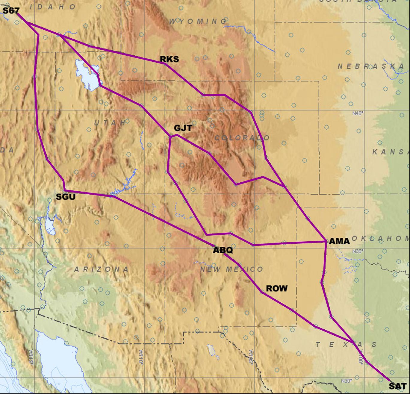
We chose several different routes during our initial flight planning process because we were covering so much ground. The weather dictates our actual route, so it’s helpful to have at least two major paths planned for a long trip. The great circle distance is 1206 nautical miles, and the routes we chose were, at most, 200 nautical miles more than the optimal straight line course. That’s pretty good considering we would need to refuel once and also had to maneuver over or around the Rocky Mountains. This map shows our initial route selections with lots of options to avoid any significant weather on the day of our flight.
I’ll be home for Christmas?
The total flying time from Boise to San Antonio would be around 9 hours. We have previously flown 8 hours in one long day (one time was from Boise to Iowa City on our way to Boston). I briefly contemplated trying to do this trip in one day, because it would be nice to actually be to Abraham’s house on Christmas Day. However I decided against trying to do that for a few reasons. The main one was that we’d be pretty tired after flying for 9 hours, so although we could physically be present for Christmas, we wouldn’t be very good company.
Another more subtle reason was to avoid “get-there-itis” which is something that happens to pilots who are trying to absolutely make it to a destination for some deadline. Get-there-itis can cloud one’s judgment, causing the pilot to press on into bad weather or with marginal fuel reserves. The final reason was we’d be pushing it to try to arrive in San Antonio before the short winter day ended. Although I really love flying at night, the parts of the flight after landing, such as navigating an unfamiliar airport and finding a parking spot, can be quite challenging in the dark. Nancy intuitively knew that trying to do this trip in one day would be too much.
The exhaustion and night arrival concerns are beside the point for me. Nine hours is just too long to sit in one day, especially since we don’t have the luxury of walking around the cabin to stretch our legs. Yes, it can be done but I’m more enthusiastic about the next flight if I don’t overindulge in one day. Also, I like stopping over in small towns that we would never consider as a destination. For this trip, that meant having Christmas dinner at a coffee shop since most restaurants would close for the night before we arrived. No worries — holidays are about who you spend them with, not where you are or what you eat.
Route Selection
I use Jeppesen’s FliteStar program to help with the flight planning process. Although you can tell the program to choose a route for you, and even select fuel stops, I rarely do it that way. I typically tell the program to plot a course straight from the departure to the destination with no fuel stops. This is useful to get an overall picture of the route, terrain, airspace, distance, etc. I’ll usually do this first step as soon as we even consider flying anywhere.
The next step is to refine the straight line route. I’m willing to fly a few extra minutes away from the straight line route to stay a little closer to airports along the way, or to fly around big mountains rather than over them. For this trip, I wanted to choose at least two significantly different routes to give us a better chance of avoiding bad weather that may appear on the day of the flight.
We chose our routes with an initial plan to fly about 6 hours on the first day, spend the night somewhere and then fly the remaining 3 hours the next morning. One fuel stop would be needed on the first day since our airplane’s fuel capacity is just over 6 hours (although we almost never fly more than 4 hours on any one leg).
(Refer to the map above as you read this part.) I looked for fuel stops that were around 3 flying hours away, and that led to choosing three initial routes. The first fuel stops for each of the three routes were Rock Springs, WY (RKS), Grand Junction, CO (GJT) or St. George, UT (SGU). After fueling in either RKS or GJT, we’d overnight in Amarillo, TX (AMA). If we chose the SGU route, then we’d overnight in Roswell, NM (ROW). Then the next morning we would fly the final leg to San Antonio, TX (SAT).
While Phil took care of the flight planning details, I researched the possible stops along our various routes. I was concerned about fuel availability on a holiday. Surprisingly, most FBO’s hours were very accommodating and didn’t seem limited at all. A few even maintained their 24-hour schedule on Christmas.
There are two good IFR routes between Grand Junction and Amarillo. The more direct one would have us climbing to 15,000 feet and taking a few zigzags through the Rocky Mountains. It would give us spectacular views of the Rockies and the ski areas, but the weather would have to be almost perfect for us to go that route. Bad weather and mountains are a bad combination. The other route runs southeast towards Albuquerque, NM (ABQ) before turning almost due east to Amarillo. By avoiding the highest mountains we could fly this route at 11,000 feet but it was a little longer route with one portion over an area with no nearby airports.
Watching the Weather


With the initial flight planning out of the way, the next thing to do was to start watching the weather. I checked the forecasts each day during the week leading up to our planned departure on Christmas Day. In general we’ve found the weather forecasts aren’t too accurate more than 72 hours in advance.
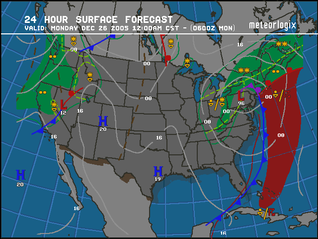
The images at the right show the weather patterns for the 25th and 26th of December. The 72-hour forecast (top image) showed a large area of high pressure would be across the main part of our route, with no major fronts forecast. On Christmas morning, the current surface analysis (middle image) was pretty similar to the 72-hour forecast. One thing that changed between the forecast and the current conditions was a cold front that popped up off the California coast, with a low pressure system and fronts that were forecast to move through Idaho and Nevada on December 26th (see bottom image).
The 24-hour forecast told us that we’d really need to depart Idaho on the 25th and delaying one day to the 26th would probably mean canceling the whole trip. This added to our pressure to try to actually make the flight on the 25th, despite my illness.
Weather for the Return Trip
When I was talking to some other pilots prior to this trip, several of them asked, “how will you know the weather will be ok for the trip back?” The answer is, you really don’t know. The only thing to do is to be pretty flexible with your schedule. If you’re on a tight time deadline, drive or use the airlines.
We were planning to stay in Texas for at least 4 days, and although weather forecasts are available that far in advance, they are rarely very accurate. The 5-day forecast was calling for high pressure for the center of our route, but a cold front coming in from Washington and Oregon towards Idaho. We try to give ourselves a few extra days of vacation to get around or wait out weather like this for a return flight. In this case, we had planned to start heading back for home on Friday and work wasn’t starting until Tuesday giving us lots of extra time for the return trip.
Planning Pays Off
When I was in the Army, an often used phrase was, “the more you sweat in peace, the less you bleed in war.” Nancy and I have certainly found that the more time we spend up front planning out a trip and contingencies, the better out experience turns out to be. It’s disappointing to have to cancel a trip after doing all this planning, but I’m sure we’ll fly to San Antonio sometime in the future. At that time we’ll be able to use much of the planning work that we have already completed.